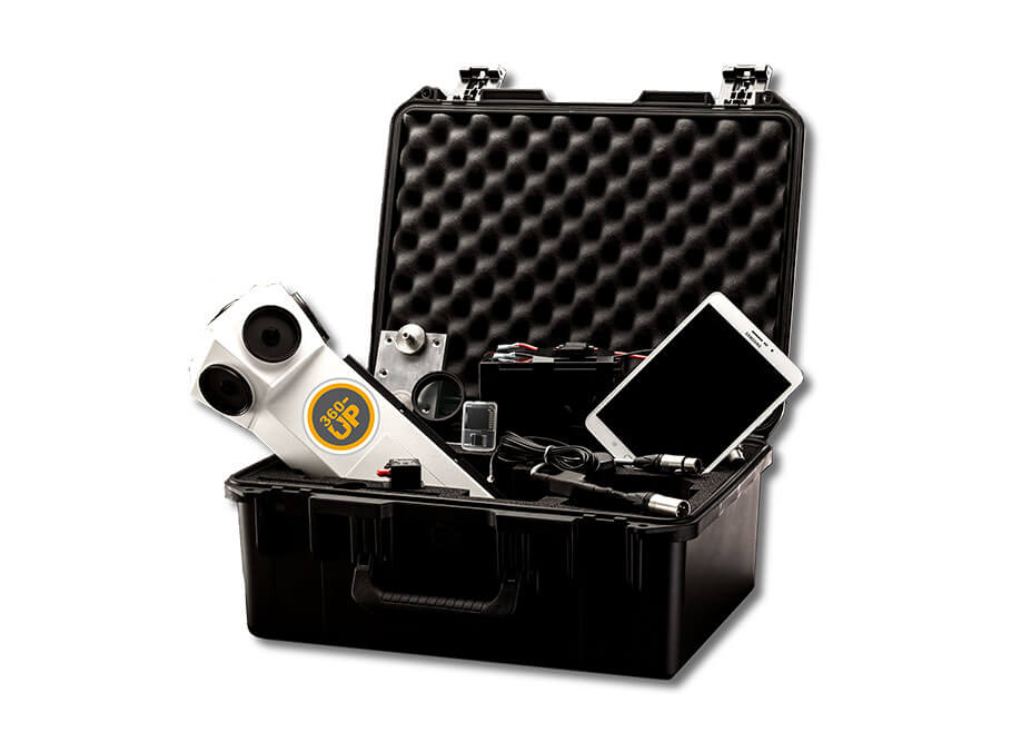
Professional set consisting of a 360°-camera with software packages and remote control. Options like vehicle mounts, backpacks and more. Create Street View yourself on Google services or without Google.
What makes the Street View hardware + software set from 360-up particular?
- Professional all in one bundle entirely engineered in Germany
- For the recording, data management and publishing of 360° Street View data
- With the new cloud based software you can publish directly to the Google Services or publish interactive Street View tours without Google
- Outstanding solution for service providers, tourism, administrations, civil protection, transport services, land registry, military and industry
Rheinuferpromenade | Düsseldorf
Virtual tour with CMS, Street View Made in Germany, Tourism
Hurricane Dorian | Bahamas
Virtual tour with CMS, Street View Made in Germany, Service providers
Specifications Hardware
360°-Camera
| 360-up Street View Camera | |
| Number of sensors | 6 |
| Sensor resolution | 5 MP |
| Sensor size | 2560 x 1920 pixel |
| Image format | JPG |
| Max frame rate | 7 fps |
| Field of view | 360° x 160° |
| Release modes | distance, interval, manually, external trigger |
| Street View log | image number, latitude, longitude, altitude, heading, GPS date + time pitch, roll, direction, speed number of satellites, GNSS Fix, HDOP, VDOP, etc. |
| Track log | Extra track recorded at 20 Hz |
| Binary log | All data packages the positioning device provides |
| Data capacity | Unlimited due to swappable SSDs |
| SSD capacity | 120 GB, 250 GB, 500GB, 750 GB, 1 TB |
| Recording capacity | With the distance release mode set to 5 meters: 120 GB SSD lasts for 120 km 1 TB SSD lasts for 1000 km Each data-set is about 4 MB 120 GB SSD lasts for 30,000 Street View images 1 TB SSD lasts for 250,000 Street View images |
| Power supply | mobileUPS for the cars cigarette lighter socket / batteries |
| Remote control | WiFi by Android controller app on the provided tablet |
| Exposure, white balance, gain | automatic |
| Dimensions + weight of the camera | height 400 mm, diametre 180 mm, weight 1,8 kg |
| Sensors | 6 Aptina MT9P031, 5MP each |
| Lenses | 6 fisheye lenses, f 2.4, fixed focus |
| Lens protection | 6 screw-on UV filters Easy to clean and replace |
| Heat dissipation | 2 large heat-sinks and an internal fan |
| Mounts | Mounts for car, backpack, boat and locomotive are available |
Positioning System
| Positioning System | GNSS with Dead Reckoning Optional RTK Optional wheel sensor via the cars OBD2 socket |
| Module | Spatial by Advanced Navigation |
| Receiver | u-blox M8 |
| Supported navigation systems | GPS, GLONASS, BeiDou |
| Accuracy improvement | Optional RTK |
| Positioning robustness | Optional OBD2 wheel sensor |
| GNSS accuracy | horizontal position accuracy 2,0 m vertical position accuracy 3,0 m |
| RTK accuracy | driving about 30 cm |
| Maximum recording speed | Recording with distance mode set to 5 meters: 110 km/h |
| RTK correction signal | RTCM 3.1 von NTRIP with the remote control tablet via LTE and Bluetooth. |
Specifications Software
Street View Data Processing Software
| 360-up Street View Data Processing Software | |
| Stitching software | |
| Processing capacity | 250,000 street views / day, with Windows 10 PC + NVIDIA RTX 2060 Super-Grafikkarte |
| Operating system | Windows 10, 64-bit |
| Street View format | equirectangular |
| Street View size | 8192 x 4096 pixel |
| Street View FOV | 360° x 160° |
| Street View format | JPG |
| Levelling modes | auto, static, none |
| Meta-data | Copyright, local recording date + time, latitude, longitude, altitude, direction, GPS date, GPS time |
Processing options with the software
- project management
- tour management
- map for visualisation + manipulation of the recordings
- duplicate remover
- watermarks
- leveling and change of brightness
- shadow brightening
- timelines
- player configuration + preview
- cloud publishing
- cloud player authorization
- cloud player statistics
- creation of datasets for web player, android player, instant player, Google publisher, only street views
- split screen mode: map + street view images
- tool for separating thin recordings
- creation tool for street names from open source maps
- tool for the setting of the direction from the position
- tool for the setup of backward mounted camera
- source copy tool
- presets
- manual
- release data
- built-in access to help desk
Optional Software-Suite
Software-Sets
| 360-up Street View Software-Suite | |
| 360-up Street View Data Processing Software | Street View Creator + Player Configurator |
| Google-Publisher | Upload to Google Street View + Google Maps |
| Privacy Controller | automatically detects and blurs faces and license plates to comply with laws, rules and regulations |
| Instant-Player | allows street views to be displayed immediately on Windows 10 computers without prior processing |
| Photogram | enables the geo-referencing of any object that is visible in a street view image recorded by car |
| Controller | Remote control to operate the camera with the android tablet. recording project management |
| Facades | matches street views to data from your GIS system extract photos to visualize points of point layers |
| Tile Downloader | download map-tiles for offline-use for the remote controller + the android player |
We are official sales partner